People don’t often look at images to see just how much information is in them. Images are *data rich* and it can be a fun exercise to see just how much information you can extract from even seeming snapshots.
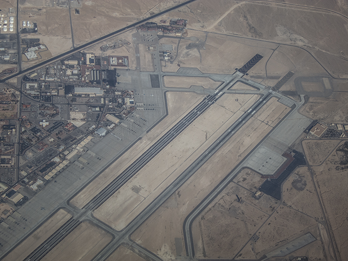
The other day flying over Nellis AFB, I pointed my little point and shoot camera out the window to grab a shot of the Northern portion of the base. It brought back memories of some aerial photography done years ago and certainly gives you some idea for how important imagery intelligence was during the Cold War. Its less of an issue now days with Google Earth, but there are still times when an amazing amount of information can be had from imagery.
For instance, if you look at the full resolution version of this image, there is lots to take in. Not only can you see the line of white Air Force Thunderbird F-16s on the tarmac, but you also see 15 non-aggressor F-16s on the tarmac, 4 F-22s sitting outside, 2 C-130‘s, a KC-135, 12- Aggressor F-16s, (I think) an F-18, a Gulfstream (500 series?), a Learjet C-21, 10 Blackhawk type helicopters, 2 Beechcraft KingAirs over on the DOE pad and 2 A-10 Warthogs in the picture. There may be/likely are additional aircraft underneath the “carport” covers and in hangars.
You can also see fuel storage facilities, some of the new solar energy infrastructure, base housing, shopping, etc… This is only the North part of the base. Just outside of this image are the Red Flag facilities I visited a couple of years ago, more tarmac parking for F-15 aircraft, ramp space for weapon installation/removal, etc…etc…etc… Lots of additional information can be obtained from imagery like this including construction, landing patterns, topology and other measures of infrastructure like how recently roads had been repaved, potential turn around time for missions, proximity to other infrastructure in cities, etc… The guy who taught me about image analysis based his career on studying things like *runway lengths* which sounds silly until you start to think about how much information that something like a runway can give you. Information like capacity, the ability to move certain kinds of equipment in and out in certain amounts of time, prevailing weather conditions, economic infrastructure and much more.
Try sitting down to one of your photographs some time and see just what kinds of information you can extract from it. Can you tell the time of day or the date (without looking at the EXIF data)? Season? Just how much information can you find in an image? Can you extrapolate how an image was constructed from light sources? Can you figure out where the photographer was standing in other photographs? Trying this exercise certainly makes you appreciate the kinds of data that can appear in a photograph, but I suspect it will also help you think more about composition, lighting and form and it can certainly teach you something about image forensics.
The enlargements are very cool. I’m sure you’ll be off to Guantanamo for posting these, but I here the weather is quite nice this time of year.
Ha! It turns out that I will be going down to that part of the world in the not too distant future. Hoping to stay away from Guantanamo though…
A good friend of mine from high school, Jim Reynolds, flew in the F-16 Aggressor Squad at Nellis. He was he died in a crash in 1993 when the F-16 he was flying *just* a little too close to the ground, in what was for him a typical “low and fast” run.
It officially went down as pilot error. But those guys (the Aggressors) constantly cheated death with the, well, aggressive way in which they flew. It was their job to train other pilots—think Viper from Top Gun.
ref: http://www.f-16.net/inmemoriam_tribute84.html
Yeah, it is a dangerous gig. The guy I was supposed to fly (Lt. Col Thomas Bouley) with down at Nellis back in 2008 flew into the ground and was killed two days before I was supposed to go up.